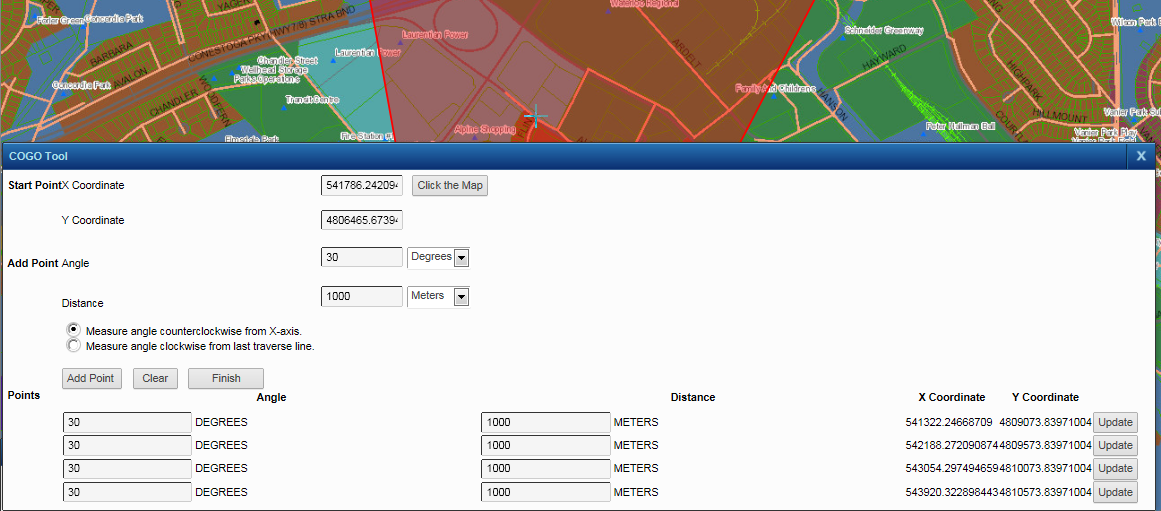
The Coordinate Geometry (COGO) tool allows you to create polygon and line features with a high degree of accuracy using coordinates, angles and distances. You create features first by entering coordinates of a starting point and then specifying all subsequent changes of direction by supplying angle and distance values from the previous vertex point.
|
You cannot use the COGO tool to edit existing features—you can only add new features.
|
|
1.
|
|
2.
|
On the Map Tools pane, click the More Tools button and then click Editing. The Editing window opens.
|
|
3.
|
In the Edit Layer field, select the layer with features you want to edit.
|
|
5.
|
In the X Coordinate field, enter the x coordinate for the first point.
|
|
6.
|
In the Y Coordinate field, enter the y coordinate for the first point.
|
You can also click the Click the Map button and enter coordinates by clicking the map in the location where you want to create the feature.
|
7.
|
In the Angle field, enter the angle for the second point in degrees or radians.
|
|
8.
|
In the Distance field, enter the distance from the first point to the second point in measurement unit selected.
|
|
The angle of the first line (between point one and two) is always measured counterclockwise from the X-axis.
|
|
10.
|
Click Add Point. A line is drawn on the map that connects the first point to the second point.
|
|
12.
|
Click Finish.
|
 |